Dive Brief:
- The City of Austin, TX has created an interactive map tracking the proximity of income-restricted housing to available transit, ahead of a Nov. 3 vote on a proposed $7.1 billion transit expansion dubbed Project Connect.
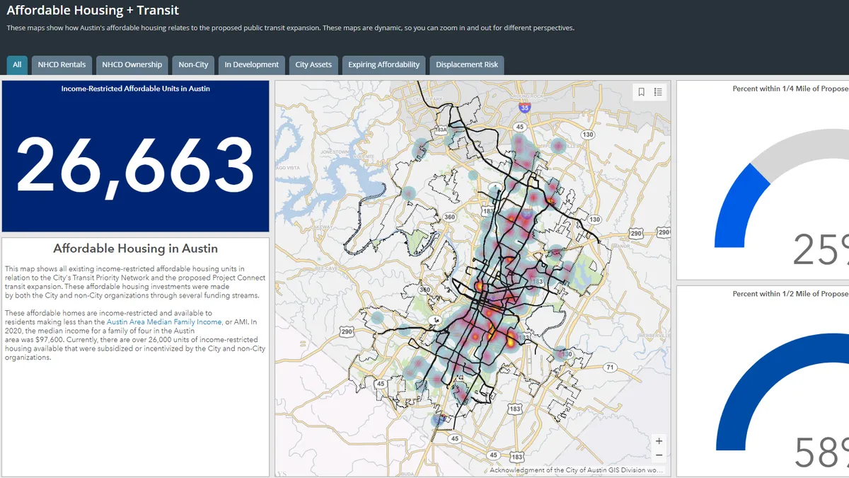
- The map, developed by the city's Neighborhood Housing and Community Development department, plots Austin’s 26,663 income-restricted affordable housing units in relation to the city’s Transit Priority Network and Project Connect's proposed transit developments.
- The tool shows that 25% of the income-restricted affordable housing units fall within a quarter-mile walking distance of a proposed Project Connect station, and 58% are within a half-mile walking distance to a proposed station.
Dive Insight:
The tool was first presented to the committee on Sept. 8 to illustrate the relationship between housing and transit.
"The department is actively creating tools to help the public see this relationship in a visual way," a city spokesperson wrote in an email interview. "This map series also builds upon years of work to develop reliable, publicly-accessible datasets that show the affordable housing inventory in Austin."
The affordable homes labeled on the map are income restricted and open to residents who make less than the area's median family income, which was $97,600 for a family of four in 2020, according to the city spokesperson.
The map shows 11,000 income-restricted affordable housing units slated to be built in the city. Fifty-five percent of those are within a half mile of a Project Connect station and 26% are within a quarter-mile walking distance. The map also displays the number of expiring affordable housing units (4,688), in addition to the location of city assets that could be used to build more affordable housing.
The tool could help support the city's overall goal to integrate available affordable housing into its transportation planning. Austin's Strategic Mobility Plan (ASMP) defines "transportation affordability" as the ability to afford the price of living in certain neighborhoods that have easier access to well-established transportation infrastructure.
And often when transportation networks are expanded — like in the Project Connect initiative — the price of living in those areas can increase, which can lead to displacement, according to the document.
There are 13,276 income-restricted affordable housing units within high displacement vulnerability areas, according to the map. Those figures could help inform Austin’s efforts to prevent further displacement if Project Connect is approved. The $7.1 billion project plans to invest $300 million of those funds to prevent the potential economic strains and displacement that can result from significant public transportation investments.
The map could also help inform Austin's other mobility goals, which include increasing the number of residents who take transit to work. The city would like to have 16% of residents use transit to travel to work by 2039, compared to 3.9% of residents who used transit to commute from 2013 to 2017. Austin also aims to improve the frequency of service, the number of transit stops, the percentage of electrified fleet and more.
Austin voters will decide on the Project Connect initiative, which would draw connections between the downtown and areas of the city, this November. The vote calls for "a tax rate increase of 8.75 cents per $100 of property value to fund Project Connect," the Austin-American Statesman reports.
Clarification: This story has been updated to reflect the income-restricted affordable housing units are within high displacement vulnerability areas.


